Tectonic Trek: Volcano cruising Mt. St. Helens in a Toyota FJ
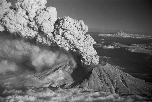
It started at 3:47 p.m. on March 20 with an earthquake, a magnitude 4.2 tremor beneath the mountain that got everyone’s attention. By early April, there was a bulge, an upwelling of hot magma rising from within and pushing out the north flank at an alarming rate, 5 feet per day. Then came the steam vents and spewing ash, and still the quakes continued, unsettling window rattlers from deep that served as regular reminders to all—the captivated geologists and nervous loggers and impatient locals and the millions of curious Americans following news reports across the country—that Mt. St. Helens, after more than a century of sleep, was up to something. Despite the two months’ notice, despite all eyes on the mountain and all hands on deck, when the eruption came at 8:32 a.m. on Sunday, May 18, 1980, it still caught everyone off guard, because no one thought it would do that.
As a Portland transplant, I’ve enjoyed a view of the southern flanks of Mt. St. Helens for nearly 20 years. Even from 50 miles away, I’m still awestruck by the mountain’s uniform steep slopes cut short by the abrupt flat top that illustrates its violent past. On the eve of the 40th anniversary of its eruption, I decided to escape my comfy, unchanging view and explore Mt. St. Helens for myself. In the process, I hoped to discover how a place and its people come back from a thing so devastating. It was an almost-perfect road trip, right out my back door.
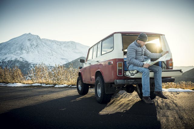
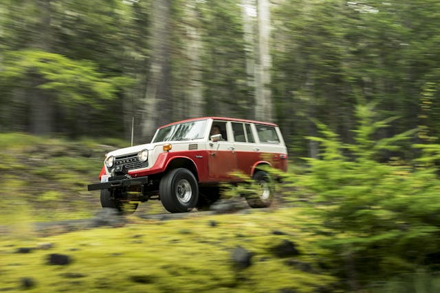
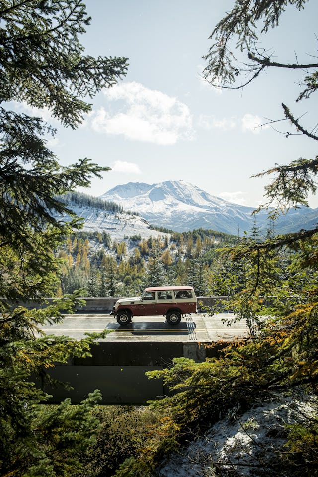
To make it totally perfect, I wanted to do it in a truck that could have been there—something I might have been camping in or fishing out of in the spring of 1980. I turned to DriveShare, the classic-car rental site and app that connects renters with owners in the same way Airbnb does with housing. A 1979 Toyota Land Cruiser FJ55 owned by Hagerty Drivers Club member Andy Yahn seemed a gift from central casting. It was lifted and small-block-swapped and lumpy with Bondo in all the best ways, so I booked it for three days in early October and planned a route on roads less traveled.
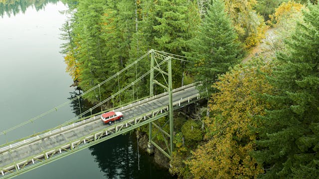
On a damp flat morning, just over the border in southwest Washington, we got onto the two-lane Lewis River Road in the woods south of Mt. St. Helens and then rode east for miles beside the long, crooked fingers of Yale Lake and Swift Reservoir. The land was hummocky there, clear-cut long ago in an odd patchwork, and the mist that clung to the hills mingled invisibly with wood smoke from every chimney we passed.
At the end of Swift Reservoir, we picked up Forest Road 25 on its 40-mile meander north. Unlined and maybe a lane and a half wide, it’s still what passes for a main drag in these woods. We’d left cell range long ago, so periodic stops to check the various paper maps on hand underscored the distances involved in our trek; by the end of day three, we covered 600 miles.
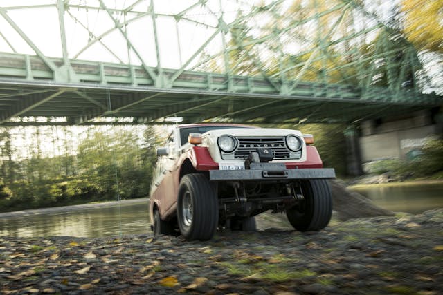
Late in the day, FR 25 finally brought us to FR 99, which is 17 miles of slick, twisting, yumpy asphalt slowly losing its grip on the unstable earth beneath it. In addition to replacing the FJ’s stock 4.2-liter six with a 350 V-8 several years ago, Yahn fitted the truck with a 6-inch lift and 33-inch tires. Over each broken bump, through each cracked swale, the FJ floated. Coupled with its lazy steering, more than once the suspension gave the unsettling sensation of going airborne.
The road took us into the back side of the 110,000- acre Mt. St. Helens National Monument, but long before we reached its terminus at a viewpoint called Windy Ridge, just a few miles from the open chest of the volcano, we drove into thick clouds. With no chance of a view and a three-hour drive to our hotel still ahead of us, we turned around—though we did stop at a place called Bear Meadow, where 40 years ago a camper named Gary Rosenquist fired off 22 photos in 36 seconds to capture the eruption’s first moments. The sequence is the closest thing to video that exists of that morning.

If the town of Castle Rock, just off I-5 on the volcano’s west side, is “The Gateway to Mt. St. Helens,” then Ellen Rose is keeper of the keys. As proprietress of the Mt. St. Helens Motel, she is the queen of all she surveys. Rose was born and raised on a farm where the nearby Toutle and Cowlitz rivers converge. “When they evacuated town, I went there,” she said. “The farm was fine, but so many logs pushed up the Toutle that it dammed the Cowlitz. My dad spent weeks walking the banks hauling stuff out of there: axles, whole trucks, logging equipment, furniture, appliances, all sorts of stuff.”

Rose and her in-laws started construction on the motel in early 1980 but shut it down after the eruption. In the months that followed, however, in the rebuilding and restoration of the land and the rivers and all the personnel that it required, it made sense to press on, she said. “We were already so invested in this thing, I thought, we might as well finish it.”
A retirement home she’d built in 1975 served as a partial model for how the motel might operate in its early years—by housing contractors. “When the mountain blew, we opened up the retirement home to workers on the rivers. All these guys running draglines and dredgers. But some of those draglines pulling stuff out, you just looked at them and wondered how the heck that was going to work. I can remember a tower on one side of the river and a tower on the other with a Sauerman bucket scooping out the goop, and most of it was just flowing back into the river. They’ll be dredging for the rest of my life.”
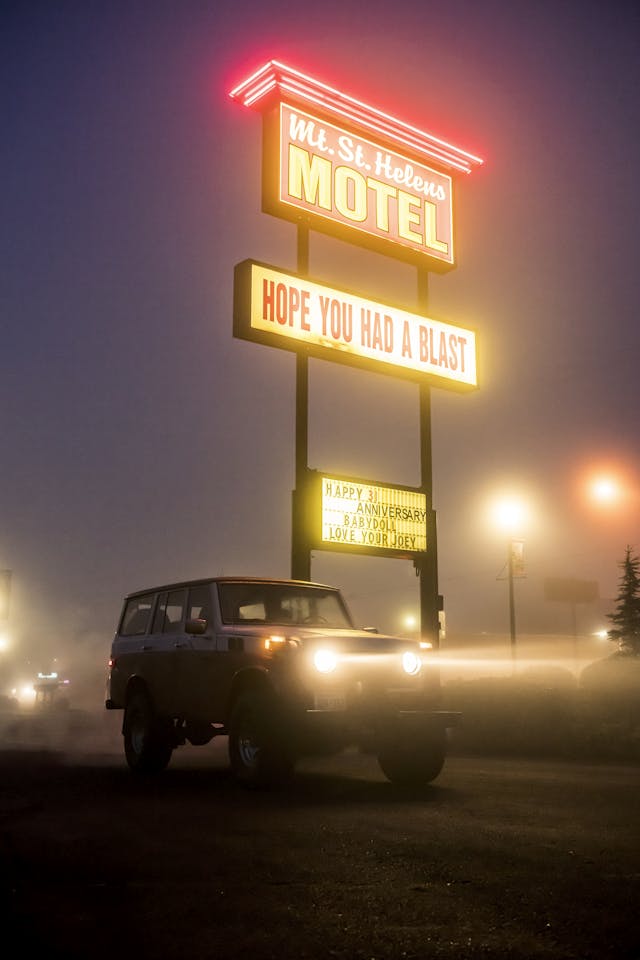
In the darkness of the next morning, thick fog clung to everything, and a 35-degree drizzle hinted at what we’d encounter higher up. The FJ, which had so far run flawlessly, refused to idle, an issue that continued the rest of the trip and required several futile adjustments of the idle screw and much throttle poking every time we even thought of coming to a stop.
Next to the motel, over too much breakfast at Peper’s 49er restaurant, our waitress rolled her eyes at the very mention of the eruption. “Our farm just got covered with ash,” she said. “It was a mess. And it took years to get rid of it, because it was in everything.”
In this area, the eruption really did affect everything, and the physics and figures behind it are mind-boggling. First, the landslide, the largest in recorded history. One final earthquake shook loose the entire north slope of the volcano and sent some 3.7 billion cubic yards of earth tumbling down the mountainside at 150 mph, where it plunged into and through tranquil Spirit Lake. It raised the entire lake bed nearly 200 feet and erased all traces of the lodges, cabins, campgrounds and ranger stations that had lined its 12-mile shoreline for decades.
Next, the blast, not up, but out. Twenty-four megatons of pent-up thermal energy moving hot gas, ash, and rock laterally at more than 300 mph. In three minutes, the so-called pyroclastic flow obliterated an area the size of Chicago, 230 square miles, including enough timber to build 300,000 two-bedroom houses.
Then, the ejecta, another 520 million tons of ash soaring up to 80,000 feet into the atmosphere in less than 15 minutes, there to linger as it circled the globe. It blanketed the western United States; in the blast zone, the gray slag was 3 feet deep; 10 miles downwind, a foot deep. In Spokane, 250 miles away, the city measured an inch of ash on everything, and even the distant Dakotas received a dusting.
Finally, throughout the late morning and afternoon came the lahars, hot mudflows 40 feet high fueled by snow and melted glaciers, all of it tumbling at 35 miles per hour down every available channel. They carried with them 27 bridges, 200 homes, logging trucks and equipment, and thousands of boulders and trees, the surge pushing all the way to the Columbia River where the shipping channel choked down from a 40-foot draught to 14 feet and stranded 31 ships upstream.
Fifty-seven people died that day, blown away, crushed by falling trees, swept off by floods, or asphyxiated by burning ash. Some were as far as 13 miles from the mountain. It could have been worse, because it could have come on a weekday morning, when the forest lands worked by timber giant Weyerhaeuser—which were in the blast zone north and northwest of the mountain—would have been alive with hundreds of loggers and their buzzing saws.
Heading up State Highway 504, the Spirit Lake Memorial Highway, our destination was the visitor center at Johnston Ridge Observatory, 52 miles away. The last 30 miles of road were destroyed in the eruption, and it was a dozen years before it reopened. As we climbed out of Castle Rock, elevation 59 feet, sure enough, the temperature dropped and the drizzle gave way to snow, flurries at first and then thick wet stuff. The FJ’s wheezy little wipers just managed to cut through, so long as we didn’t stop and let it accumulate. And we did that often. We’d come prepared to get stranded, with plenty of food and water and survival gear—but not a window scraper, so each time I needed to really clear the windshield, I put it on my corporate credit card, literally.
Spirit Lake Highway cuts into the heart of Weyerhaeuser logging country, and the stark differences in forest management since the eruption are on display once you enter the blast zone, which extends nearly 15 miles to the northwest of the crater. Inside the monument, the mandate was to leave the land be and let nature reclaim it. By contrast, Weyerhaeuser wasted little time in getting to its 68,000 decimated acres. The company lost three entire camps and dozens of crew buses, trucks, and railroad cars that served them, plus 650 miles of roads, 16 miles of rail line, and 12 million board feet of logs, buried by ash or swept away by mudflows. But a two-year salvage operation began almost immediately. By all accounts, it was brutal, hellish work, not only because Mt. St. Helens erupted four more times during the summer of 1980, but because every movement in that lifeless gray moonscape sent clouds of fine ash into the air. One logger compared it to working in Tolkien’s Mordor. But at the peak of activity, more than a thousand loggers were removing 600 truckloads of salvaged timber each day—850 million board feet in all. By 1987, the company had hand-planted 18 million Douglas and noble fir seedlings for the next generation of growth, slated for harvest in 2026.

We arrived at Johnston Ridge Observatory in the late morning, the straight-piped FJ blasting our arrival. A few weeks before shutting down for the winter, tourist traffic was almost nothing, and ours was the only vehicle in a lot sized for summertime crowds.
You walk through a cut in the ridge up to the building, and the distant volcano reveals itself to you with each step. Finally, you come to a railing, where you stand 2000 feet above the Toutle River valley and stare into the gaping maw of the crater 5 miles away. That’s how it’s supposed to work, anyway. But up there, at 4300 feet, the snow was flying sideways that day in a sharp wind, the temperature had dropped to 20, and visibility was nil.
Built into the ridge top, its roof garnished with pumice and downed trees, the observatory is a buttressed single-story concrete block with floor-to-ceiling windows facing the mountain. It is named for David A. Johnston, a volcanologist who died at age 30 on this spot while monitoring Mt. St. Helens for the U.S. Geological Survey. Johnston was one of the first scientists to arrive that spring, and from his perch on what was then called Coldwater Ridge, he had an unobstructed view into the volcano. It proved to be disquieting, so much so that a few weeks prior to the eruption, another geologist had put in a request with the Washington State National Guard for an M113 armored personnel carrier to be delivered to the outpost as an escape pod in case of eruption. On May 18, the carrier was en route, slated for delivery that afternoon. But in the violence of the event, not even a tank would have saved David Johnston.
The exhibits inside offer visitors a glimpse of Mt. St. Helens both before and after. There’s a large three-dimensional topographical map, the rare stories of survivors to read, and a glimpse at the science behind the mountain. What we wanted, of course, was a view, and the observatory could not give us that, so off we went.
As we walked back to the Land Cruiser, two busloads of schoolchildren were coming to a halt across from us. And though the entire lot had been empty, someone in a Jaguar F-Pace had parked right beside us. Snow shrouded both SUVs, the black Jag a perfect lozenge, the red-white-and-rusty FJ an imperfect block. The kids were preteen and noisy, but when we reached the truck, a few of them shouted their approval. A young bearded man came over to us then, a chaperone or teacher, to tell me how much he loved the FJ and to ask questions about its age and its engine and its ability to do things and go places. Not a single person cooed or cared about the Jaguar, though I, for one, envied its seat heaters.
Back down the hill, we stopped at Drew’s Grocery in the little town of Toutle. For 83 years, Greg Drew’s family has owned the place, which sits a half-mile from the confluence of the north and south forks of the Toutle River, where Weyerhaeuser’s equipment and so much else came roaring through in the lahars. Drew, who was 30 at the time, remembers being at home in his robe when the phone rang. “We got a call from one of our employees saying the mountain had erupted,” he said, “so we went out in the yard and started watching the plume.”
A couple hours later, the mudflow alerts came. “Quick as we could, we locked the doors and got out of there to evacuate to higher ground,” Drew said. “We’d been told there was a 200-foot wall of water coming our way. Thankfully, that wasn’t true.”
Having grown up around Mt. St. Helens, Drew took the devastation hard. “It was such a horrible loss. Most people around here had such strong emotional ties to the mountain and to Spirit Lake. My dad took me out on the lake fishing every summer. My wife and I couldn’t stand to think of what was gone, so it was about three years before we finally took a helicopter flight up over the mountain to see for ourselves.”

Mt. St. Helens is one of two dozen major volcanoes that form the 700-mile-long Cascade Volcanic Arc, from British Columbia to Northern California. As the Juan de Fuca Plate continues to creep beneath the North American Plate, the volcanoes of the Northwest stew silently and, every century or so, erupt violently. As mountain-building goes, the Cascades are whippersnappers. The Appalachians, for example, are 300 million to 500 million years old, the soft, rounded relics of an era when coal was trees and organisms began to slither out of the sea. The aptly named Rockies are far younger, only 55 million to 80 million years old, while the jagged Sierra Nevada are an even fresher 40 million years old.
The volcanoes of the Cascades are all less than 2 million years old, most far younger than that, including the ever-changing Mt. St. Helens. It’s been brewing through periods of eruption and dormancy for roughly 40,000 years, but the symmetrically perfect 9677-foot cone that went off in 1980 was just 2800 years old. There are trees older than this mountain.
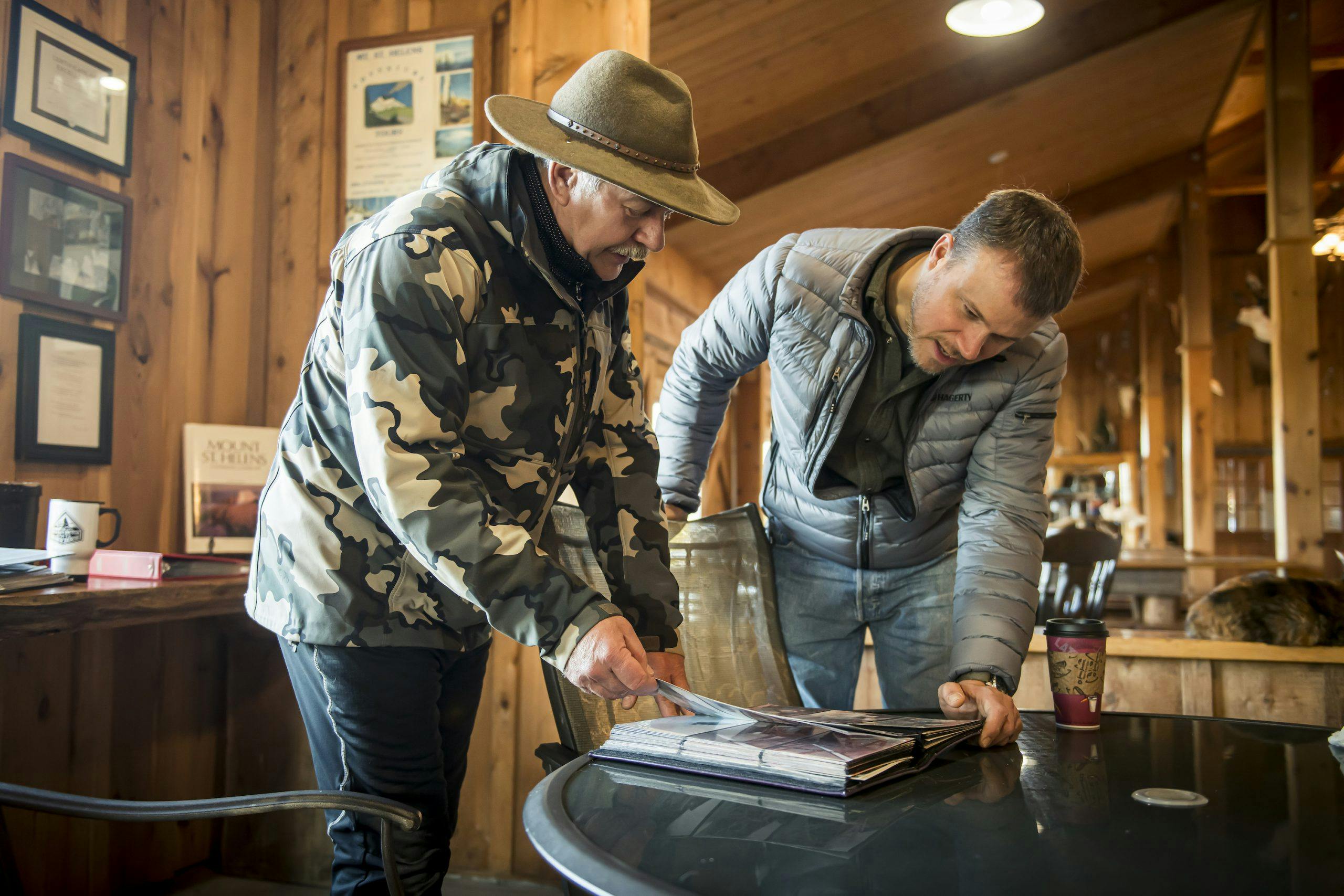
It is best viewed on a clear day, too, which is what we awoke to early on the final morning of our expedition. The plan was to drive back up to the monument, then down again and backtrack our route from the first day, north and then east and then south down to Windy Ridge. But first I had to talk to Mark Smith.
Smith is the man behind the Eco Park Resort, an 80-acre spot off 504 that offers cabins, horseback tours, a restaurant, and spectacular views of the Toutle River mud plain. By 1980, his family had owned Harmony Falls Lodge for seven years, one of three lodges on the banks of Spirit Lake. Back then, he was a 20-year-old kid who’d grown up around the mountain and knew everyone in those woods, including Harry Truman. This was not the 33rd president of the United States, but the drinking, cussing, cat-loving 83-year-old curmudgeon who built the Mt. St. Helens Lodge in 1939, and then became a nationwide celebrity in the spring of 1980 for refusing to leave it despite a mandatory evacuation order.
Today, Smith recalls that weekend with a clarity that comes from having escaped the thing that killed his old friend. “We’d all been cleared out of there for three weeks,” he said. “Everyone but Harry. But then the mountain started to quiet down, and we started demanding to be allowed back in.”
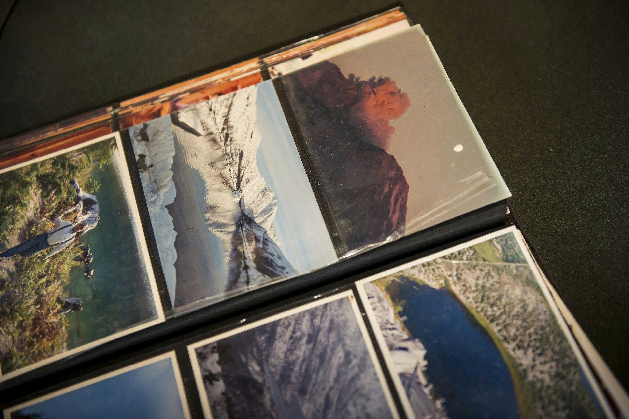
On May 17, the day before the eruption, 140 people signed waivers at the police roadblock on 504. “It was a carnival,” said Smith. “I’m in my Jeep with my brother, no top, Jimmy Buffett playing, no clue where I’ll go if the mountain blows, but we all thought it was our right to get in front of a volcano and get killed.” Smith’s mom wanted him to grab the family’s photos from the house, “but once everyone was up at the lake, it was like a party. We fired up the grill and kicked back.”
They went to see Harry. He thought things were quieting down, too. He gave Smith’s brother a grocery list, then said, “See you tomorrow.” By the time Smith got back to his lodge, the state patrol was kicking everyone out, and he never did grab those photos.
The next morning, Smith and his family watched the plume ascend into the sky from their family home in Castle Rock, unaware they were seeing the eruption. The peculiar sound dynamics caused by air motion and topography meant that no one within a 60-mile radius of the mountain heard a thing. Hundreds of miles away, meanwhile, windows shook and people reported a massive explosion or enormous thunderclaps. “It was like a silent movie of a nuclear explosion,” Smith said. “Completely in black and white, except for the lightning, which was blue, yellow, and red inside the plume.”
Smith jumped in his Jeep and headed for the mountain. A sheriff’s deputy had the road closed at the Coal Bank Bridge, up from Drew’s Grocery, and the two of them watched as the leading edge of the lahar rumbled around a bend. “It was full of logs and equipment, and when it hit that bridge, there were little puffs of smoke, poof-poof, and the bridge went. Didn’t buckle, didn’t roll over. Just got picked up and taken with.”
Even after all this time, the awe and excitement of the 20-year-old racing a volcano in a Jeep CJ is crystal clear in Smith’s tone. But then he gets to about 1 o’clock that day, when he finally got home to find the rest of his family around the TV, and the sadness of it all comes into his eyes. “I came running into the living room, ‘Man, you won’t believe what I’ve seen!’ But no one was listening, because the first video from the helicopters was just coming back. It was these National Guardsmen, and they couldn’t find Spirit Lake because it had completely changed shape. Couldn’t see the lodge, couldn’t see anything. Most natural disasters leave a wake of debris. But there was nothing. Everything was gone.”
Once back on the highway, we finally caught sight of the mountain, colossal, jagged, and towering above everything else around it. It was shield-your-eyes bright in its fresh coat of snow, a dazzling cauldron of potential energy. By late afternoon, we were back on the east side. A dozen miles from the mountain, we entered the blast zone, so different from the managed land of Weyerhaeuser. There was new natural growth but also tens of thousands of pale logs on their sides everywhere you looked, all of them stripped of their bark and branches in an instant and most of them felled in the same direction—away.
The pyroclastic flow that claimed them was denser than the air around it, and driven by the explosive force, it moved like a fluid. But instead of being diminished or diverted by the thousand-foot ridges it encountered, it slithered at 300 mph up and over them and then down the other side, clearing everything in its path. These trees, some hundreds of years old at the time, never stood a chance. To see them like that and to think of the 57 people who were out among them that Sunday morning—campers, mostly, but also loggers, amateur and professional volcanologists, a lone grouch holed up in his lodge—is a sad, somber punch to the gut. How immediate it was, how final, after so much idle threat.
At Windy Ridge, I sat on a stone wall and stared into the volcano. It looked like a wound, broken open and spilling its ragged discharge as a giant pumice plain. A few miles across the plain, I could just make out the observatory. The sun was low and pale orange, and it lit up the valley beyond, which ran for miles down toward Mark Smith, Greg Drew, Ellen Rose, and the rest of the world.
Below me, an enormous log mat sat unmoving across the cold surface of Spirit Lake, the result of the landslide sloshing all that water 800 feet up the ridge beyond, only to gather up and drag every fallen tree in its path back down with it. A chipmunk appeared and took me in for a moment before scurrying across the ground beneath my dangling feet. That chipmunk was the latest in a line of small creatures responsible for bringing life back to this area. No one envisioned flora or fauna returning in any meaningful way for years, if not decades. But snow was still on the ground that May, and many of the little critters burrowed beneath it survived. When they finally emerged into a changed world, their tiny stored-up meals became tiny poops, a million seeds scattered across the land. Winds brought insects, spiders, and more seeds, mostly fireweed and pearly everlasting. Eventually, a single prairie lupine appeared on the pumice plain, then entire patches.
We debated waiting out the sunset. The light would be spectacular coming up the valley and setting the volcano ablaze. The trade-off would be 75 miles of icy forest roads in the dark. It had been three long days in this tough old Toyota truck—in the mist, in the snow, in the sunshine. We had seen the mountain, and it was time to go.

The article first appeared in Hagerty Drivers Club magazine. Click here to subscribe to our magazine and join the club.


Great story. Interesting timing with its release, as Hwy 504 is now closed at MP 43, right at the Mt. St. Helens Science and Learning Center due to a landslide a short time ago farther up the road where a creek crosses under the Hwy. WSDOT has no idea when it will reopen. https://www.flickr.com/photos/wsdot/sets/72177720308336123/
This was a good story, remember reading it in the magazine. Love the FJ and the pictures of the area near Mt. St. Helens.
Your comment is awaiting moderation. – Again