1923 road trip diary End of the road Part VII
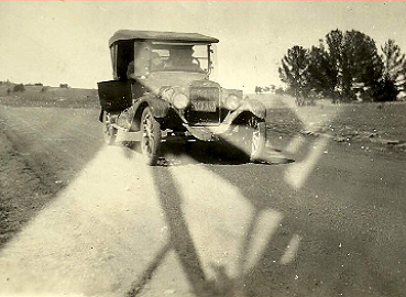
Table of Contents
Part I: Getting Started
Part II: ‘The Car and Our Spirits Proved Weatherproof’
Part III: The ‘Yellowstone Trail’ into South Dakota
Part IV: A wet ride to Yellowstone
Part V: Whirlwind tour of Yellowstone
Part VI: To the Pacific
Part VII: End of the road
Map of the journey
Edgar “Ned” Wilcox was a school teacher and elementary school principal near Traverse City, Mich., in the early 1900s. In 1923, Ned and his wife Golda, sister-in-law Josephine “Josie” Landon, and brother-in-law Lloyd Landon set out in Lloyd’s Case Six automobile on a cross-country road trip to Tacoma, Wash., eventually settling in California.
Ned took the time to document his trip in a manuscript for friends, family and students. The story remained hidden until 2007, when his grandson uncovered the document in some old family papers. It’s reproduced here verbatim, transcribed from a typewritten manuscript, with 1923 words, phrases, language and cultural references. It’s a glimpse of American life and car culture more than 85 years ago.
Part I: Getting started
By Edgar “Ned” Wilcox
In a moment of thoughtlessness I promised that I would write a description of our trip, and let you pass it around. As I have been working on the “manuscript,” I have found it to be much more of a task that I had anticipated. I have tried to be brief, but, if this is brevity, then it is a good thing that I didn’t go into detail, otherwise you would never finish reading – for the simple reasons that I never would have finished the writing.
About the Case Six automobile
The J.I. Case Threshing Machine Company manufactured the Case Six automobile in Racine, Wisc. The 1920s Case automobile was on a long 125-inch wheelbase with a Continental “Red Seal” six-cylinder engine manufactured in Muskegon, Mich. It was considered an “assembled” car, albeit in the highly competitive middle-class price range (competing against Reo, Studebaker and Oldsmobile, for a few examples). The Case Six in our story is a Touring Car: a four-door convertible without side glass. This was the most common automobile body style until after 1923, when closed cars became more affordable to the general public for the first time.
The only brakes our intrepid travelers had were mechanical rear foot brakes and an emergency brake behind the transmission; at best, their service brakes were as effective as our current emergency brakes in modern cars. A scary thought, considering that on many of the tiny roads through the Rocky Mountains there weren’t any more than a few inches extra width on either side and no guard rails.
Also, the cars of the day had no seat belts, no radio, no heater, no air conditioning, no power steering and no power brakes.
A few general facts first, then I’ll follow events much as they took place. We left Traverse City, Michigan, at 3:30 Monday afternoon, June 18 and arrived in Tacoma, Washington on Friday evening July 6 – about 10:00. We were thus eighteen days enroute; but we lost a total of three days on account of rains and waiting for repairs, so that we were on the road only fifteen days, and out of that fifteen days, we spent two days in Yellowstone Park. Our speedometer showed a total of 2,762 miles, or an average of a small fraction over 184 miles a day. Our gas record showed a little over 12 miles per gallon; and our total expenses for gas, oil, repairs, eats and hotel bills were $180.00, or $45 for each of the four of us, or 1.6 cents per mile per person.
In all that first leg of our journey, we did not have a puncture or blow-out; our only accident was a broken spring. We had to have the foot-brake repaired in Minneapolis, and we had both brakes re-lined just before we entered the Park.
We slept in hotels just three nights because of poor camp sites in rainy weather. The rest of the time, our little 8X10 tent sheltered us at night, and our two-burner American Kamp Kook prepared our meals. Later, in our three trips between Tacoma and Los Angeles, we slept under a roof only two nights, but we ate a larger percentage of our meals in restaurants.
Our equipment consisted of the tent mentioned, two double folding cots, four camp stools, and a big running-board box which held our food, cooking utensils, and bedding. This box is 58 inches long, 24 inches high and 10 inches wide; the top and one board on the side are so hinged that they drop back on folding legs and form a table. The two folding cots were wrapped in black oil-cloth and tied on the other running-board, the doors of the car swinging over them; the tent lay on the fender beside the engine, and the jointed tent-poles were tied on top of the running-board box together with some of the extra wraps. The ladies were pretty well packed in the back seat with two suit-cases, a traveling-bag, a shopping bag, and all the other odds and ends. Lloyd’s car is a Case Six and proved its well deserved reputation for power on heavy roads and steep grades.
Part II: ‘The Car and Our Spirits Proved Weatherproof’
When we left Traverse City, we planned to go first to Frankfort and, if we could not get a car-ferry there across Lake Michigan, to go on to Ludington and catch the evening boat for Milwaukee. We got away rather late and missed a car-ferry for Manitowoc by an hour. It took us so long to find out definitely about the ferry that we hadn’t time to make the boat at Ludington. But we were assured that there would be a ferry across the lake some time the next forenoon. So we drove to Crystal Lake, a few miles out of town and camped for the night.
When we got up the next morning, it looked pretty rainy, so we hurried our breakfast. We had just finished, when it began to sprinkle; we packed up in a hurry, got into the car, and started for Frankfort; but it was soon raining so hard that Lloyd couldn’t see to drive and we pulled out beside the road till the storm let up a little. It seemed like a rather bad omen, but both the car and our spirits proved to be weatherproof.
Arriving in Frankfort, we found that a car-ferry would leave for Menominee about eleven o’clock. This was not just what we wanted, but it seemed the best bet under the circumstances, so we engaged passage. The trip across the lake was uneventful, and we arrived in Menominee at 6:00 P.M. We decided that we would feel more as if we were “getting on” to get out of Michigan, so drove over to Marinette, Wisconsin and had supper at a restaurant. Having rested on the boat, we decided that we would drive to Green Bay – about sixty miles – and camp there. Good paved road all the way, but it had rained early in the evening and the pavement was slippery, so we drove slowly. On reaching Green Bay, we found that the Tourists’ Camp was at DePere, about five miles west; but we finally located it and made camp about eleven o’clock.

Thursday, June 21. We were up early and found a bright, clear sky. Had our breakfast and were on our way before 7:00. The country we passed thru that day was much the same as the day before, but possibly more hilly. The self starter had gone on a strike the day before, and we soon grew tired of cranking that big “six,” so we stopped in Eau Clare and had it repaired. We crossed the St. Croix river bridge at 4:30, paying a toll of forty cents for the privilege. At the highest point of the bridge we saw a sign that marked the western boundary of the state – and the next moment we were in Minnesota. We had a long stiff climb of five or six miles up out of the valley of the St. Croix and then a like drop down to the valley of the Mississippi. We passed thru St. Paul and into Minneapolis without knowing when we did so. Our first objective here was to find the local office of the American Automobile Association. Lloyd is a member of the Detroit branch of the A.A.A. and as such is entitled to free service from all branches. Minneapolis proved to be the hardest city in which to locate anything that we found in all our travels. Nobody seemed to know exactly where anything was, or if they did, were unable to give clear, definite directions to anyone else. But finally, about six o’clock we found the office, only to learn that it had closed at 5:30 and not be open again till 8:30 the next morning. Then we started out to find the camp grounds and had another long search. Even the police did not seem to know just where it was, only that it was “down on the bank of the Mississippi River”, and there wasn’t a sign anywhere to direct us to it. But, like the office of the A.A.A., we finally found it – in a big woods on the bank of “The Father of Waters.” There were a hundred or more tents there that night.
The next morning we went to the A.A.A. office and got our maps and general information. Then we went over to the local Case agency and had a little repair work done, including new lining in the foot brake. It was nearly noon when we left the city, but we found good roads most of the way and reached Montevideo, 145 miles west, in time for an early camp.
Part III: The ‘Yellowstone Trail’ into South Dakota

About the
Yellowstone Trail
The Yellowstone Trail was the first transcontinental automobile highway through the northern United States. Conceived by J.W. Parmley of Ipswich, S.D., in 1912, it ran from Massachusetts to Seattle.
The automobile was quickly growing in popularity, but there were few good, all-weather roads for driving enthusiasts. The Yellowstone Trail was created amid a nationwide effort for internal improvements.
The Yellowstone Trail Association had small town chapters and state chapters to oversee routing. Local “routing committee men” went out into their counties to find the best roads available and then talk county governments into spending tax dollars on that route. They then persuaded little towns to join the organization and to pay a small fee to be included on the route publicity.
The Yellowstone Trail Association played a role similar to the AAA’s today. The group did not build roads, but instead lobbied government for “good roads.” It also published maps and brochures, established information bureaus in busy hotels, and set up tents along busy places on the trail to hand out these materials.
The popularity of the Yellowstone Trail dwindled during and after the Great Depression. The association disbanded in 1929-30 with the original Yellowstone Trail Association, although a replacement organization, the Yellowstone Highway Association, operated until about 1939.
Source: www.yellowstonetrail.org
At Minneapolis, we struck the “Yellowstone Trail”, and this we followed to Spokane except when we deviated to go into the park by the eastern entrance. This trail
is well marked – a yellow square (about 16″ square), bearing two black circles between which are the words “Yellowstone Trail,” and in the center a black arrow pointing toward the Park. This sign came to be a faithful guide and friend to us in the hundreds of miles that we followed the trail in Minnesota, South Dakota, North Dakota, Montana, Idaho, and as far as Spokane, in Wash.
Along the trail in Minnesota, we saw many of the beautiful little lakes for which this state is famous. The land is more level than that of Wisconsin and the farms much larger. We still saw many fine large fields of alfalfa and clover, but more of corn, wheat, barley and flax. Many fields contained 160 acres, and frequently there were several such fields of the same crop on one farm. This state claims the finest road in the U.S., and we did travel over many miles of gravel roads as smooth as pavement.
Montevideo has a fine large campground of about 35 acres, heavily wooded but with an open grassy space of some two acres right in the center. But the facilities were meager – common out-door toilets, only one pump, and no kitchen or stoves of any sort. They boast a “swimming pool,” but it was only a big mud hole possibly sixty feet in diameter and not over three feet deep – I judged the depth from some children who were playing in the “pool,” I did not try it myself. It rained hard during the night but did not bother us any, except that we delayed our departure a little the next morning to let the roads dry off some.
Saturday, June 23. We had fine gravel roads clear to the state line, and crossed into South Dakota at Big Stone City about 11:30 A.M., and found but small patches of good roads for nearly two weeks – until we reached Washington. Here we began to see the sage brush, the cattle ranches and the “wild and woolly” cow punchers. Mighty friendly fellows, those cowboys; always gave us a friendly greeting.
The land in the Dakotas is much the same – largely a series of hills, or buttes, and valleys with sometimes quite extensive plateaus on top of the buttes. We would wind and twist and turn up over a butte or range of buttes then wind and twist and turn down to a valley 5, 10, or 20 miles across, only to climb another range, cross another valley, and climb another range. Nearly every valley had a little village or city, the trading center of the surrounding region. In some regions grain is raised quite extensively but mostly it is horses, cattle and sheep that one sees along the trail. However we did not pass thru the largest cattle region. At Forsythe, Mont., we were told that the biggest cattle ranches were about 100 miles to the south.

What struck me most were the vast distances and the sparse population. We would stop on the summit of a hill and looking for miles and miles in every direction, we could count the houses, mere shacks, on the fingers of one hand. Just out of Scranton, N.D., we stopped for a view that a friendly rancher had told us about. We were crossing a range of buttes at the time; at the highest point of the road we stopped the car and climbed to the top of the butte. Forty-five miles to the north-west we could see the Chalky Buttes; thirty-five miles straight north, the Rainy Buttes; to the south, seventy-five miles away in a long straight line stretched the Slim Buttes; and at a like distance to the south-west were the Cave Hills. And in all that great area we saw only a half-dozen buildings. And when we crossed the Missouri River (by ferry) at Mobridge, S.D., we were warned to load up with gas and oil as we had 80 miles to go with only one small town on the line – about mid-way. Yes, and it was 16 miles from the river that we saw the first house, and that was vacant.
But the people of this section are the most friendly to the tourists of any place that we have been; no wonder, for they must be glad to see anyone in those lonely places. Wherever we stopped we were absolutely sure of two things; first the question, “Where you from and where you going?” This answered, our purchases made and our questions answered, and, as we turned to go came the parting, “Well, goodbye and good luck to you”. Honestly we hardly stopped at a store or a garage or gas station, halted a passer-by for directions that we did not get the hearty, “Good bye and good luck to you.”

One day we saw a big swarthy cowboy loping toward us. We decided that we would like a “close-up” of him so stopped the car, and, as he neared us, hailed him. With a touch of the rein he brought his horse dancing up to the side of the car. Then, catching sight of the ladies in the back seat, he smiled pleasantly, his white teeth gleaming against the background of his leathery face, and with an easy, graceful movement he slightly lifted his great hat. He answered our questions fully. We thanked him and stepped on the starter. As the engine responded, the horse leaped away, but his rider, swinging gracefully to the movement, again lifted his hat and called out, “Good bye and good luck to you.”
One more illustration of this spirit. Just out of Lemmon, S.D., we were stuck in a “gumbo hole.” Gumbo is a composition peculiar to the soil of this section of the country; when wet it is just like grease, and a car, even with chains on, is as helpless in it as a rube on a polished floor. But an hour or so after the sun is out it is dry, except in spots where it is present in a larger proportion, and there it remains wet, black, slippery, and treacherous.
This particular hole extended clear across the road and was filled with water. On one side was a grassy ridge about a foot wide, and Lloyd figured that he could keep two wheels on that and get by all right. But about half way across, the wheels slipped off so that the car straddled the ridge and out momentum drove the front axle deep into it. In vain we tried to back out. A big Hudson Six that had camped near us the night before, came up, took our tow rope and tried to pull us off, but couldn’t budge us. A boy came along on horseback. We asked him what he would charge us to get a team and pull us out. He replied, “Oh, about a dollar. I have been stuck myself.” But the team was only a pair of half wild broncos and couldn’t move us. It looked as if we would have to send back to town for a tractor to get us out. Just then a mud spattered flivver carrying three husky, sun-burned ranch hands approached from the west. They sailed straight thru the hole till on dry ground then stopped their car and came back to offer assistance. They had hardly made the offer when another car with three more ranch hands came up from the east. They swing around the first car, plowed thru the gumbo, parked their car on dry ground and also came back to help. You see, both of these cars followed the rule (and you may be sure that we did after that) “when you come to a gumbo hole, hit ‘er square and hit ‘er hard.” One of the fellows walked over to the fence, kicked the wires loose from a post and pulled it out. Taking my camp ax, he split off one corner so that he had a small plank. We jacked up the rear wheel that was hanging over the ridge and put the plank under it. Then Josie got in and started the engine, the six ranchers, Lloyd and I lifted and pushed, the team pulled, and out we slid. We thanked our helpers most heartily, and they said that they were glad that they could help us, and they said it as if they meant it. As they piled back into their cars they all waved at us and shouted, “Good bye and good luck to you”. Can you beat that spirit? Put on a khaki suit and strap some luggage on your running board and you have the key to the West.
But we have more to remember about Lemmon, S.D. than our experience in the gumbo, but I must not get ahead of my story.
Let me see, where were we? Oh, yes, just entering South Dakota. We camped that night at Aberdeen. A fine camp here with many conveniences, but rather crowded when we were there – about a hundred cars with four or five hundred people. A very friendly spirit exists among these “knights and ladies of the road.” No introductions necessary; great fun swapping experiences and discussion each other’s equipment. This was one of the few camps in either of the Dakotas or Montana that boasted shade trees. They had a fine kitchen with free gas stoves. But we rarely used the public kitchens – too crowded. We preferred to use our efficient little Kamp Kook. But we did occasionally enjoy the shower baths after a hot dusty day.
Sunday, June 24, we were up early for we planned to camp at Lemmon that night and we knew that we had 225 miles of poor, rough roads ahead of us. Just before noon we ferried the Missouri river, and it was here that we had that 80 miles with only one small town on the road. We reached our day’s destination shortly after six o’clock and found the Tourists’ Camp a vacant lot, warm and brackish water, and not a tree in sight. There were several tables with benches, donated by various business firms of the town and bearing their advertisements; these were all already taken, but we did not mind as we had our own table and stools.
Here I experienced some difficulty in pegging down the tent. The ground was baked so hard that it was all we could do to drive in the large wooden pegs such as we commonly use in Michigan. But once we got them in, they were equally hard to get out – a fact that we were thankful for before the night was over. Later, being unable to secure iron pegs, I got some 60-d spikes, made a ring at the head with hay-wire and found that they worked quite as well as any. Our camp was so exposed here, and the wind was blowing so strong, that, just before we rolled in, I went the rounds of the pegs and ropes again and then ran an extra guy rope from the top of each end pole–one to a big peg, and the other I tied to the car, which stood across the front of the tent. The only weak point in our defense against the elements (and it came near being our undoing) was the hinge in ridge pole. I had noticed that it was getting weak when I put it up and remarked that I would get a new hinge the next day.
We had hardly dozed off when we were awakened by the wind and rain. It hit us suddenly and hit us hard; the little tent bent and swayed and snapped and flapped under it. And at the second gust, the ridge pole broke. The only thing that kept the tent from collapsing at once was the two end guy ropes. The girls stood up on the cots and held up the middle of the broken ridge pole, while Lloyd and I each braced against an end pole. It seemed every second that something must give way under the terrific force of the wind. I knew that if once one guy rope snapped, others would follow in quick succession and away everything would go. I had a mental picture of our tents, cots, bedding, and clothing being scattered over the northern half of the state. Just as the tension both on the tent and our nerves was the highest, Lloyd let go of the tent pole with one hand and began feeling around the cot. Josie called out sharply to him to “hang onto that pole.” But Lloyd replied coolly, “Well, if this outfit blows away, I want to hang onto at least my pants and my money.” I suppose we all instantly got a mental picture of what a predicament he would be in without either and we all laughed, and the laugh eased our nerves. In about ten minutes from the time it started the storm quit as suddenly as it had started. I slipped into clothes and stepped out to see how the rest of the ten or a dozen tents had weathered the blow. Everyone was “present” with all their belongings, but all declared it a mighty close shave. With a stick and a piece of small rope I spliced the ridge pole, propped it up with an old board, and we went back to bed, but I don’t think anyone in that camp slept very soundly the rest of the night.
The next morning we learned that we had had the edge of a tornado that had passed thru the southern part of North Dakota about 25 miles north of us. It had demolished houses and barns, and killed stock and some eight or 10 people. We crossed its path about noon, and then we realized what a narrow escape we really had had, and how much we had to be thankful for. We saw the remains of an eight- or 10-room house that had been carried 40 yards (I paced it) from its foundation and smashed to kindling wood; the whole thing was as flat as the ground it lay on. Of the nine people who had been in the house at the time of the storm, four were killed, and we could not see how anyone got out of that wreck alive. All day long as we passed near this region, we saw results and heard tales of the blow that kept us nervous at every little puff of wind till we were well out of the plains, and in the shelter of the mountains.
The next day, Monday, June 25, soon after we started out, we stuck in the gumbo hole as I have already told you; so between the tornado and the mud I think we will not soon forget Lemmon, S.D. And, frequently, all that day we found gumbo holes in the road. When we could go clear around them, we did so, but otherwise, we “hit ’em square and hit ’em hart.” We were always a little afraid that there might be a rut in the bottom of the hole that would give us a bad jar, and at first we all braced ourselves as we went into a hole. But hole after hole we slid thru smoothly and easily, throwing a great spray of black mud and water till it got to be a sort of joke. In the afternoon, the gumbo holes became less and less frequent.
But finally Lloyd saw a big one ahead, and calling out “Look out for gumbo” he went straight into it. I sat, perfectly relaxed, thinking how smoothly we would slip thru the mud. But right in the middle of that particular hole there was a deep cross rut, and we “hit it hard” all right, all right. Being so entirely unprepared for it, I started to make an ascension that might have rivaled Elijah’s if it hadn’t been for the top of the car. It is a mighty good top or I certainly would have gone plumb thru it; as it was it gave so much that a camp stool under the straps in the top shaved my chin twice-once on my way up, and again on my way down. The girls were pretty badly shaken up too, and they started to scold Lloyd but stopped when they saw me laughing; I laughed until the tears ran down my face, and finally the rest got to laughing just seeing me laugh, tho they couldn’t imagine what tickled me so. What was I laughing at? Why, at myself, at how darned surprised I was when we hit that bump. Here I was sitting all relaxed and smiling to myself as I thought how smoothly we would glide thru that mud hole, then we hit that rut and I started skyward. I was like a big jack-rabbit, sitting on his haunches behind a bush and thinking he is all safe, when, Bang! He gets a charge of shot in the part that is nearest the ground and straight up he goes.
Part IV: A wet ride to Yellowstone
The trail from Lemmon runs parallel to, and just south of the northern boundary of the state, crossing over into North Dakota near Thunder Hawk. From here it crosses the southwestern part of North Dakota and thru the southern end of the Bad Lands. The rock formations thru the Bad Lands are wonderful and we were sorry that we couldn’t see more of it. We reached Baker, Mont., about 6:30 and made camp there. Good camp here but treeless. Wonderful big kitchen, dining room and wash room (with stationary tubs), and free gas. The Chicago party that had camped near us the night before and that had tried to pull us out of the gumbo hole, camped near us again here, and we got quite chummy and stuck together for some time.

We had a cold night at Baker, but the next day, Wednesday, June 26, was hot and dusty. We crossed buttes and valleys all day. About one o’clock, we drove into the fine big Tourists’ Camp at Miles City, ate our lunch and rested till 3:00. When we started out, we planned to drive to Forsythe and camp there, but were forced to stop at the little town of Rosebud, twelve miles short of our destination, by a heavy rain; we drove into a garage here just short of a heavy downpour. There was no camp site here, and beside the “ladies of the party” hadn’t yet gotten over their experience the night before, so we secured rooms at a nice clean little hotel and put up for the night. Our Chicago friends also put up at the same place.
The next morning, June 27, (my birthday) started clear, and we left Rosebud hoping to reach Billings by night. But we made our low record run that day – just 12 miles. For, just as we drove into Forsythe, it began to rain and it rained all day. As soon as we had decided that it was no passing shower, we drove down to the camp grounds, but one look was enough; they were on low ground and fairly swimming. As we drove back up town, we saw a sign “Rooms”; we went in and found a fine place where we could get an excellent room with hot and cold running water all for $1.50 per day. We took the only two vacant rooms and settled down for a good day’s rest. Oh, the girls took advantage of the occasion to wash out a few things while they were resting.
We knew that even if it was clear the next day it wouldn’t be wise to start before noon, and if it was still raining, we wouldn’t start at all; so, when we went to bed, about 9:00 that evening, we settled down for a real sleep, and we all “slept the clock around”. But when we did open our eyes, it was to find the sun shining brightly and a warm drying wind blowing. We dressed and packed up leisurely and then hunted up a good restaurant and stowed away a big combination breakfast and dinner. As we were taking on gas just before leaving town, a man across the street, seeing our Michigan license plate, came over to greet us – it proved to be Charlie’s friend, Mr. Arbaugh of Lansing.
We left town about twelve o’clock. For 12 or 15 miles we had graveled roads but we had heard that beyond the gravel the roads were in frightful condition because of the rains. We met a number of cars coming from the west and stopped them to inquire about the roads. The drivers seemed to be of two opinions about the roads. One would say, “Oh, the roads are H–, but you can get thru”. While the next driver would say, “Oh, you can get thru, but the roads are H–“. Well, they both spoke the truth. You known it is said that a motorist’s idea of Heaven is “a place of good roads and no speed cops”. Well, then his idea of the other place must be just about what we found that morning. There was a half mile of clay with ruts hub deep, three-fourths of a mile where a creek had over flowed its banks and the road was under a foot to eighteen inches of water, a mile and half detour over a ploughed field around an impassable mud hole, and a few other pieces of road of like nature. The men who had described the road in the morning were correct in both their statements; it was all they said it was, and still we got thru. But about 50 miles from Billings we struck gravel roads and again and made camp in that city fairly early, pitching our tent next to our Chicago friends who had pulled in just ahead of us. A fine, large, wooded, well-equipped camp here – and over two hundred cars there that night the care-taker told us.
We did not break camp very early the next morning as we all expected mail here and had to wait till the office opened. Here, too, we decided to go into the Park by the eastern entrance, so a few miles west of Billings we left the Yellowstone Trail, which leads to the north entrance, and took the “Billings-Cody” road down across the northwestern part of Wyoming. It was a hot day, that 29th of June, and the “road” was, in many places, but a mere trail twisting and winding over hills and across almost un-inhabited semi-desert plains. Climbing over one of these hills, our engine began to heat up, and we discovered that the radiator was clogged so that the water was not circulating freely, and all the rest of the day we had to stop frequently and let it cool. Shortly after the engine trouble began, we broke the main leaf of a front spring while going over some very rough road. A clogged radiator, a broken spring, and thirty-six miles of desert country between us and the nearest town! Just one of the interesting experiences to tell about afterwards. When we started out that morning, we had hoped to reach the entrance to the Park by night, or at least get to Cody, fifty miles from the Park. But under the circumstances we were lucky to get into the little city of Powell, about twenty-five miles from Cody, shortly before 6:00. We wanted to get our repairs made that night, but the best we could get was a promise to do the work the first thing in the morning. The camp grounds here were barren, dirty, and uninviting, so we secured rooms for the night.
Powell lies in a valley surrounded on three sides by bleak, barren hills. But the valley is crossed and re-crossed by great irrigation ditches filled with water from the Shoshone Reservoir and is wonderfully fertile.
The next morning we decided that while we were laid up for repairs we had better have both the foot and the emergency brakes relined and generally overhauled as we would be in the mountains the next day. So, it was 3:00 P.M. when we hit the trail again – a fine gravel road all the way to Cody.
Cody is “Buffalo Bill’s own town”; his old ranch is about fifty miles to the south; and the town is full of relics, pictures, and stories of the famous character. We spent some time going thru museums and picture galleries and saw many interesting relics of early western life. We saw a number of guns claimed to have been used by Buffalo Bill in Indian warfare. But I presume that if he actually used every gun that claims that honor, he must have had a man at his side to hand him a new gun every time he took a crack at a Red Skin.
We had planned to drive on to the entrance to the Park that afternoon, but were advised not to do so as the road thru the Shoshone Canyon is narrow, crooked, and has many sharp turns and steep grades; moreover, at that hour of the day, we would meet many of the big twelve passenger busses returning from the Park, “And they drive like sin, and will scare you to death on that road if you are unused to canyon driving”. So we pitched camp in the fine big camp ground just at the edge of town. We were lucky to get in early for by dark the camp was fairly packed with tents, guy ropes over-lapping and cars parked as closely as on a city street. In the evening, we all went down town and it surely was a novel sight to us – a typical western town on Saturday night with the streets full of cowboys in their best regalia, big hats, bright colored shirts and neckerchiefs, and high-heeled boots. All of the men of the town wore those big hats, and many of the women did too. I saw a particularly large hat at the edge of the sidewalk and was just thinking that someone must have lost it, and was wondering whether I dared to pick it up as a souvenir, when it suddenly tilted up towards me, a tanned little face peered up at me, and a voice to match piped, “Shine?”
We were up early the next morning and broke camp without stopping to eat breakfast – packed that to eat later. A very little ways out of town we began climbing the foot hills towards the mountains. Always just at our left was the Shoshone River. Sometimes the road would wind away from it for a ways, and then come back to it again. And every time we returned to the river, we were noticeably higher above it. Then suddenly, we rounded a huge rocky cliff — and we were in the canyon, the road only a narrow ledge cut out of the mountain side. On our right, the cliff rose almost straight up for hundreds of feet, and at our left, just beyond the wheels, it dropped down steep and rocky, down, down, three hundred, four hundred, possibly five hundred feet to where the river roared and boiled over its rock strewn bed. Ahead of us that narrow road dipped steeply down, so steep that no one can depend upon his brakes but goes down in “low”. A few hundred feet ahead the road turned sharply out around a huge rock and seemed to come to an abrupt end. Looking down that steep, narrow road and out over the place where it seemed to end, we could see almost down to the river. An artist might paint that scene, or one gifted with a flow of language might make you see it, but I will defy anyone to describe my sensations as we went down that grade and out around that rock, seemingly into empty space.

called the Buffalo Bill Dam.
When we reached the Shoshone Dam, we stopped to look around and to take some pictures. The dam is 325 feet high and is said to be the second highest dam in the world. It supplies water for irrigating thousands of acres of land; and we were told that there is water enough stored in the reservoir to last for two years if not another drop of rain fell in the meantime.
A few miles beyond the dam we passed out of the canyon proper. At the first place where we could pull out beside the road, we did so and halted for breakfast. The sun was bright and clear, but the air was cool. On either side of us, not more than half a mile away, were snow clad peaks with the snow line probably not over a thousand feet above us. Nearly all the way from the canyon to the Park entrance we passed thru the most wonderful rock formations, scenery quite as beautiful in its way as anything in the Park itself.
Just at the entrance to the Park we stopped at a Ranger Station, paid our fee of $7.50, had our fire-arms sealed, and were given various pamphlets telling us what to see, where to see it, and how to conduct ourselves properly while seeing it. Then a sticker was put in our windshield to show other Rangers that we had paid our fee and were entitled to all the rights and privileges of the great natural playground which Uncle Sam has fixed up for his big family.
Part V: Whirlwind Tour of Yellowstone
Soon after we entered the Park, we were in the Sylvan Pass, an eight mile climb over the mountain ridge that guards the eastern entrance to the Park. We climbed and turned, up and up, with mountain peaks rising sheer on one side and dropping off as sheer on the other, and the grades steep and long. At this high elevation motors use about 50 percent more gas, heat easily, and have less than their usual power, using one lower gear than they would in a lower altitude. On one particularly steep grade, Lloyd started to shift gears, but in some way killed the engine; he slammed on the emergency brake, but so steep was the grade that we began to slip back.

I was prepared for just such an emergency and had my hand on the handle of the car door and my eye on a handy rock with which to block the car. The girls were so packed into the back seat that it generally took them several minutes to crawl out, but, in spite of this handicap and my preparation, they both beat me out of the car – they didn’t stop to open any doors. Josie started right up the side of the mountain yelling, “Jump, Lloyd, jump. Never mind the car.” But even before I had the rock behind the wheel, Lloyd had turned the car and was running it back toward the bank where it would block itself. Just before this we had filled a gallon glass jug with cold spring water, and Josie was carrying this on her lap at the time the car began to slip back. She had leaped out with the jug still in her hands. Both girls decided that they preferred to walk to the top of that grade, and when they got to the top, Josie suddenly discovered that she was still lugging that jug.
President Harding on the ‘Majesty’ of Yellowstone 
In June 1923, President Warren G. Harding set out on his own cross-country “Voyage of Understanding,” in which he planned to meet ordinary people and explain his policies. In late June, he made it to Yellowstone, where he gave a heartfelt speech on the park’s beauty and its profound effect on his spirit. He spoke these words just a day before our Case Six travelers saw him along Chittenden Bridge. Here is an excerpt from his speech:
“It is a very great pleasure to be greeted so cordially by so many of you on this Sabbath evening. We have been spending two wonderful days in your vicinity. And we spent this Sabbath day, I believe, quite as close to God Almighty as though we worshipped in temples erected by man, for we spent the day amidst the grandeur, the majesty, and the inspirations of the great Yellowstone National Park. …
“I have been marveling at our experiences of the last two days. During that time we have seen literally a fine cross section of the citizenship of our land. I believe that during my brief sofjourn in the park I have greeted personally travelers from every state in the American Union, and, in addition to that, I have had the privilege of greeting citizens of England, of Canda, and of Cuba. Manifestly all the country is beginning to turn its face toward the Yellowstone National Park, and I am glad of it, for there is nothing more helpful, nothing more uplifting, nothing that gives one a greater realization of the wonders of creation than a visit to that great national institution. …
“Not so very long ago I heard the pastor of a Washington church deliver a sermon in which he admonished his congregation never to allow the uncommon things to become common. If I could convey his though to you, I would urge you never to allow the grandeur of the mountains and the majesty of this great western country to become so common to you that you will lose the ability to appraise the value of their inspiration and worth. You live in a wonderland, indeed, and we who have come from sections further east have been marveling and indulging in the most extravagant comment of admiration and approval.”
Harding’s health prior to his trip was poor; at the end of July, while traveling south from Alaska through British Columbia, he became seriously ill. He arrived in San Francisco, where he died on August 2, little more than a month after our travelers encountered him in Yellowstone.
Just above this grade the road makes a complete circle not over two hundred feet in diameter, passing over itself on a bridge. Here we stopped to enjoy the scenery, cool the motor, put some fresh water in the radiator, and pack a few snow balls from a nearby snow bank, just for the novelty of snowballing on the first day of July. About a mile further on we reached the summit, 8650 feet, and here were snow banks on both sides of the road. Then we dropped down about three thousand feet to the Park proper.
Tho we were in the Park only two days, I could not write about all we saw in the same length of time. The Park is beautiful everywhere. In a number of places the Rangers have cleared out and equipped fine camping grounds; and in many other places they have put up signs indicating “Good Camping Place”.
One of our first stops was the Mud Geyser and the Dragon’s Mouth. The first is just a big puddle of constantly boiling mud. The latter is a hole in a big rock out of which boiling water surges with a sound much resembling the pounding of waves on a rocky shore. Our next objective was “Artist’s Point” on the east side of the canyon. We drove for several miles along the beautiful Yellowstone River to the Chittenden Bridge. Here we found a large number of cars lined up and halted. We fell into line and halted. Inquiring as to the cause of the hold up, we found that President Harding and his party were up at Artist’s Point and the Rangers were holding the road for his return. We got out of the car and walked down near the bridge. In a few minutes the President came past, and as he went by, he lifted his hat to us — and the rest of the crowd that had assembled at that point. Our camera clicked along with a number of others, and you may be sure that we prize that little snap-shot of the President, especially in view of his death just a few weeks later. The President out of our way, we went on to Artist Point. This is a high point on the Yellowstone Canyon. Away at one’s left is the Upper Falls, and the same water runs in what seems a mere trickle a thousand feet below you. And the rocks on all sides are most wonderfully colored — all the colors an artist could imagine.
A drive of twelve or fifteen miles from Artist Point brought us to the Norris Geyser Basin. Here is a space of several acres covered with hot springs. A board walk permits one to walk across the area close to the boiling, steaming springs. Many of them are named because of peculiar features; there is the Black Growler with a black deposit around its mouth and the escaping steam making a constant growling noise like some great bear. The steam escapes from the Hurricane with a sound that reminded us rather unpleasantly, of the night at Lemmon, S.D.
From here we drove thru the Lower Geyser Basin with its many beautiful and fantastic sights to the Upper Geyser Basin where are located the big spouters; Giant, Grotto,
![Artist Point, Yellowstone National Park. [Source: Tobi 87]](https://media.hagerty.com/media/wp-content/uploads/uscamediasite/images/story-images/2010/10/roadtrip14.ashx?w=175&h=233&as=1&la=en&modified=20170725055605&hash=AAAAE6493C1F53FF21A129789E08E4E31ADF0AA4)
Riverside, Old Faithful, and numerous others of lesser fame. Old Faithful Geyser is the only big one that we saw in action. At the Upper Basin there is a large hotel, a store, a ranger station, and a large, well-equipped camp ground. Just as we arrived here we saw a crowd collecting and were told that Old Faithful was due to spout in a few minutes so we joined the crowd around the mound of the geyser. This mount is formed of deposits from the geyser and is about one hundred feet in diameter and its apex is probably ten feet higher than the surrounding ground. Soon after we approached, we heard a deep rumbling and then water boiled out of the cone; in a minute it “boiled over” again; this was repeated several times, and each time the water shot a little higher into the air. Then suddenly, with a mighty roar and the hiss of escaping steam, a column of water two feet in diameter shot straight up for a distance of about one hundred fifty feet; this height was maintained for nearly three minutes with very slight variations. We saw an eruption after dark with a powerful searchlight from the hotel playing on it; and we were up to see it in the light of the rising sun.
There were hundreds of tents at Old Faithful camp that night and among them our Chicago friends who had come in by way of Livingston and the north entrance. We were warned to take good care of our food at night as the bears were very tame and often visited the camp at night and helped themselves to whatever they could find. After watching the evening eruption of Old Faithful, we sat around the car visiting. Finally Josie announced that she was going to bed and started around the rear of the tent, keeping well away from the tent so as to avoid the guy ropes. Suddenly she let out a scream, “Oh, here’s a bear”, and came tearing back toward the car right over the guy ropes. A careful search with a flashlight failed to reveal any bear, but Josie declared that even if we did not see a bear, she heard one, and I am very sure that she thought she did from the way in which she hurdled those ropes. Not having time to take in all the Park, we doubled back on our tracks the next morning to the Norris Geyser Basin and left the Park thru the north entrance.
The pass thru the mountains on the north is called The Hoodoo Pass because of the queer rock formations and the great piles of rocks left by some early earthquake or volcanic action. One cut thru the mountain is called The Silver Gate because of the gray or silvery coloring of the rocks. Another is called The Golden Gate also named from the color of the rocks. The delicate colorings of The Angel Terrace begger description — pure white, the most dainty pink and green, rich browns, etc. etc. The Mammoth Hot Springs are not pretty but are magnificent because of their height and extent.
We camped at Livingston, fifty miles north of the Park that night, July 2. Fine large camp site here in heavy timber. We slept soundly after our strenuous, exciting days in the Park, but responded promptly to the clang of the alarm clock at 4:00 the next morning.
Part VI: To the Pacific
A hearty camp breakfast and we were on the road by 6:00. A few miles out of town we overtook a flock of three thousand sheep (ewes and lambs) and had some job getting by them without committing “murder”, but finally succeeded. We had some bad dirt roads that day, and climbed over the Rocky Mountains, passing the summit of the “Continental Divide” about mid-afternoon. On the west side of the mountain, we found a fine, wide, smooth road leading down to Butte; it is a new road recently completed by the national government, and is called the Harding Road. We passed thru the great mining city of Butte and camped at Anaconda twenty-six miles farther on.
Here was the first camp we had struck where a fee was charged, but the comforts of the camp were well worth the 50-cent fee. It is a fine, wooded site on the bank of a little river. It is entirely closed by a high wire fence and a care-taker is always on the ground. There were plenty of out-door stoves with fuel already cut; there was also a large kitchen with four cook stoves and several “sinks” with running water – both hot and cold; in the same building was a large dining room with tables and benches. Near this was the “community house” containing reading room, toilets, and shower baths. The toilets and showers were as neat and clean as any private home. It had been a hot day, but the nights in that altitude are cold. Snow clad peaks were all around us, and the care-taker told us that the camp ground had been covered with two inches of snow just a week before. No night-shirts that night; we kicked off our shoes, pulled on an extra sweater and crawled into the blankets.
Wednesday, July 4. We started our celebration of the day by turning out at 4:00 A.M. in a snappy air like our late fall mornings. A roaring fire in one of the kitchen stoves felt mighty good, and we ate our breakfast on one of the kitchen tables, close to the fire. Several of the other campers joined us in the kitchen, not because they wanted to get up so early, but because they were so cold that they couldn’t sleep.

We had rough roads all that day, over mountains and thru canyons. At one place, going down a mountain side, we made four steps down by the sharpest turns and shortest “straightaways” we saw anywhere. From the top “step” we could see the other three right below us; the “hair-pin turns” were as sharp as the big Case could make without backing up, and the straightaways were all about the same length–about two blocks. We had a little guide book with us that gave the list of towns in every state where tourist camps are maintained and described the facilities of the camps. In the back of this book was a list of places where there are landing places for airplanes. Frequently when going over mountains like this, I would grab up this book to see if there was a landing site down at the bottom.
We had hoped to get out of Montana that day, but two hundred miles over rough mountain roads was enough for one day, and when we reached St. Regis, a little village at the foot of the Bitter Root Mountains at 7:30 we were all ready for a big supper and an early bed. A fellow camper there told us that he had left Spokane, Washington at 3:00 that morning and had gotten into St. Regis only a half hour ahead of us. He told us that the roads were very rough–but I think he used some other adjective than “very,” and that the nine mile climb over the Bitter Roots was something awful. He had come down the worst side, and we had to go up it – nice prospect to go to bed on. But it was forgotten almost before we hit the pillows for sleep comes quick and sound when the days are long and the camps short.
We were off at 5:30 the next morning without eating breakfast. We had about sixty-five miles of mountain roads for a starter. The first fifteen miles carried us over the “Camel’s Hump” and down into a canyon; so far the roads were fairly good, but from then on we hit the bumps. The sixteen miles thru that canyon was something fierce; it really was no road, just a trail. Heavy travel during recent rains had cut deep ruts which were now hard and dry. Added to this were large rocks right in the road that one could hardly get over or around. Then we struck the nine mile climb to the summit of the Bitter Root Mountains, and the road up the mountain was just as bad as that in the canyon – combine such roads with sharp turns and steep grades (some of them 20 %) and you have something to test the powers and endurance of both cars and occupants. About two miles from the summit, we decided that our suppers were well settled and pulled out on one of the few wide places and had breakfast. If any of you are troubled with “loss of appetite” and would really like to get good and hungry, let me suggest that you arrange to take that trip up the east side of the Bitter Root Mountains before breakfast, and if that doesn’t make you hungry enough to eat anything and also everything that is set before you, then you may well give up your case as hopeless.
Biking the Yellowstone Trail
In the summer of 2010, Jim Marx decided to bike across the U.S. following old Yellowstone Trail. He retired two years ago as operations vice president of a Michigan auto parts company because of problems with his heart. After noticing that he felt better when he walked for exercise, he decided to hike the Appalachian Trail. After his six-month trip, his heart problems disappeared and he looked for another physically challenging adventure.
On May 23, he set off on his journey from the Seattle ferry dock — a terminus of the original trail once it was extended to the Pacific after 1925. While the trail follows many interstate highways today, original dirt roads still exist along a great portion of the trail. Marx tried to follow the original trail as much as possible, taking back roads and even heading across a field or two.
On July 26, he reached Plymouth, Mass. 3,657 miles in a little more than two months — a pace almost rivaling the Wilcox’ Case Six.
Read about his journey on his blog: jimarx.tumblr.com
[Source: The Billings Gazette]
A few miles past the summit we crossed the Idaho state line and found much better roads till well past the city of Wallace. It was coming down these mountains that we found a real “switch-back”, a turn so sharp that a car has to back up once to make it. The road was built out at the angle to make room for backing, and a heavy log railing prevented danger of going over the mountain side. We found rough dirt roads all thru the middle of the state, but they were very good the last twenty or thirty miles. We ate our noon lunch beside one of the pretty little lakes in the western part of the state, and crossed the line into Washington not long afterwards.
We were in Spokane, the western terminal of The Yellowstone Trail** a little after three o’clock, several hours ahead of the time predicted by our friend at St. Regis, so we decided to add a few miles more for good measure. We secured such maps, information, and supplies as we needed, worked our way thru the traffic of the city, waved good-bye to the last Yellowstone Trail sign, and took “The Sunset Trail” for farther west. After the roads we had been over for the last two days, you can well imagine our delight, when, as we left the city, we saw, stretching away ahead of us, miles and miles of paved roads. Lloyd stepped the old Case up to a 45-mile clip and we rolled into the village of Wilbur, sixty-eight miles west of Spokane for an early camp. Fine free camp here with sheds for cars, kitchen with electric stoves, dining rooms, and shower baths.
We figured that we were about three hundred miles from our destination, Tacoma, and, as we were assured that we had good gravel or paved roads all the way, we determined to sleep there the next night. So that last day, Friday, July 6, we were on the road at five o’clock. We rolled over sixty miles of fine roads, and then stopped at Soap Lake for breakfast. I was delegated to give the restaurants “the once over” till I found a good one. The very first one I looked into was clean and inviting; I opened the door for a better view and was greeted by the odor of hot, wheat cakes. I waved to the others in the car, and shouted, “Come on. Here’s where we eat”. Our morning ride had not been as strenuous as that of the day before, still sixty miles in the fresh morning air gives a five flavor to “a stack of hot cakes”.
About the middle of the forenoon, we wound up over a bluff and then down to the great Columbia River, which we crossed on a ferry. Then up out of the valley to the top of bluffs again, where we had a fine view of the valley. It had been cloudy and threatening all the morning, and about 10:00 it began to rain. It rained all day, and some of the time it fairly poured. The fact that we had good gravel roads was the only thing that made travel at all possible, but at that we drove slowly, and it was 9:45 that evening when we drove up to Mr. Landon’s door, with three hundred ten miles to our credit that day in spite of the rain, and two mountain ranges.
We had a wonderful time at Tacoma. The Landons made Golda and me as welcome as tho we had been part of the family. Mrs. Landon is a wonderful cook, and such meals as we had! It seemed as if all we did was to eat and sleep; sleep the clock around every night and eat three big squares every day, with now and then a nap and a lunch in between. We took several side trips from here, including a day in Seattle, a visit to the U.S. battleships in the harbor, and a week-end at Pacific Beach. Had a great time at the beach; it is about a hundred miles from Tacoma; we drove over one Friday afternoon, part of us in Mr. Landon’s Maxwell and the rest in the Case. We arrived late in the afternoon, secured a cottage, and started in to do all stunts that one may do at such a place, shell hunting, surf bathing, and crab fishing. Catching those big sea crabs was fun, but we had to be very careful that they didn’t catch us.
A friend of Mr. Landon’s, a Mr. Walker, spends quite a lot of time at this place and knows all the “ropes”. He told us that if we would come down to the beach at 6:00 Saturday morning (when the tide would be out) we would drive down the shore about four miles to some big rocks where we could get plenty of crabs. Mr. Landon, Lloyd, and I were the Johnnies on the spot the next morning with the Maxwell. When the tide is out it leaves the beach hard and smooth and a fine track to drive a light car on. We covered the four miles rather slowly however, for it was very foggy and we could see only a few feet beyond the car. Sometimes we would be far enough out to see the surf, and then we couldn’t see the shore; and when we could see the shore we couldn’t see the sea. (See?). Arriving at the rocks, we soon began to find crabs. Lloyd, having the longest reach, wielded the fish pole – a common garden rake. Spying edge of a shell or a claw sticking out of the mud at the bottom of one of the pools around the rocks, Lloyd would rake ’em out. He got so interested in the fun, that when he saw a big one beyond his reach, he waded right in and hauled him out. We caught twenty-five altogether, and had a big feed for dinner – that is, it was a “feed” for those who liked crabs, but not for me, as I am free to confess I don’t hanker for them.
**The Yellowstone Trail was expanded westward after 1925, two years after the Wilcox’ trip
Part VII: End of the road
We “hit the trail” again July 17, heading south. Our first day’s drive brought us to Portland, Oregon, where we had a fine visit of several days with my old friend, Tom Dunsmore. One of our side trips here was to The Dalles, ninety miles east of Portland on the Columbia River. The road to The Dalles is over the famous Columbia River Highway, claimed to be the most beautiful scenic highway in the world. It is a broad paved road crossing the Cascade Mountains by such easy grades that any can drive all the way in high. Yet, so crooked is the road as it winds over the mountains, that in one place one travels a mile and a quarter on forty acres. Tom had some insurance business that called him some fifty miles farther east into the great wheat region of eastern Oregon. I went with him in his little Ford coupe and saw thousands and thousands of acres of wheat just being harvested by the great “combines” that cut and thresh the grain at the same time. Some of these huge machines were drawn by large tractors and some by horses – usually thirty to thirty-six. Some teams!
We left Portland about noon on Friday, July 20, and headed for San Francisco. The route thru Oregon is a series of valleys separated by mountain ranges. But we were on the Pacific Highway, and it was all paved except here and then a short stretch under construction. The mountains were all heavily wooded and the valleys very fertile, and every one contained one or more pretty, thriving little cities. We made camp that night at Eugene about 130 miles south of Portland. Practically all the tourists’ camps in Oregon and California have a fee of fifty cents a night for each car. Some of the camps are maintained by the city or village in which they are located, and many of them are owned and conducted by private parties. On the whole they are very well equipped. The next day, we drove to Ashland, Oregon, 210 miles; we had lots of mountains that day, in one place we climbed four summits between two valleys.
We left Ashland about 8:30 the next morning, and soon struck the steep eight-mile climb to the summit of the Siskiyou Mountains. So constant and so steep is the grade the motors heat and radiators boil frequently. But there are numerous mountain streams along the road where one can get fresh water. Sometimes, when we stopped for water, several cars would go sailing by us, but we were sure to pass them at the next watering place.
About eight miles past the summit, while still winding down the mountains, we came to the state line, clearly marked by the end of the pavement, for California lacks 125 miles here of completing its part of the Pacific Highway. Some of that road was pretty rough, but most of it, especially thru the mountains and canyons was very good. Just after we crossed into California, we saw, away to the south, old Mt. Shasta with its snow clad peak towering over 14,000 feet above sea level. All day we traveled toward that peak, and late in the afternoon, a detour carried us right past the foot of the mountain. It was a desperately hot day, and down in the valley there we were sweltering with the heat, and we could look right up thru the tree tops and see snow. One of the pretty parts of this drive is thru the canyon just north of Yreka; for about twenty-five miles the road winds right along the river where they have cut thru the mountains; there was the river on one side, just a few feet below the road, while on the other side the mountain wall rose high above us. We wanted to reach Redding, the end of the dirt road that night, but about 7:30, while still in the mountains over thirty miles from that town, we saw a fine big pine grove beside the road and a sign, “U.S. Forest Reserve. Free Camp”. The presence of a little farm on the other side of the road assured us of water, so we drove in and made camp. While the facilities were very meager, we all pronounced it one of the finest camping spots we had struck. The air up there in the mountain was cool and fresh; there were only two other cars there, and the quiet of that camp after the noise of the big camps was certainly mighty good, and had a fine sleep.
We had had our breakfast and were on our way by 7:00 the next morning. At Redding, we struck the pavement which extends from this point, unbroken to the Mexican border. Here begins the great Sacramento Valley lying between the Coast Range and the Sierra Nevada Range; it averages approximately fifty miles in width, east and west, and extends some two hundred miles north and south. The highway runs thru the middle of the valley, and we could see those great grain ranches stretching away on both sides of us from mountains to mountains as level as a floor.
We pitched our tent that night at a little wayside camp thirty miles from San Francisco Bay. I forgot to say that we had our first blow-out while coming down this valley. But we had no kick at that, for over 4,700 miles without having a tire off is a pretty good record when one considers the country and the roads we had traversed. Also wanted to say that it gets HOT in this valley. It was 110 degrees that day, and in the park where we stopped to eat our noon lunch, they told us that it was 115 degrees the day before. But it is claimed that no one is ever prostrated with the heat there because the air is so dry that it does not suffocate one; but it burns like the air out of a hot oven.
The next morning we drove to Valleo, ferried over to the Oakland side and a drive of seventeen miles brought us to that city. We stopped here an hour or so to call on some people that we used to know at Old Mission, and accepted their invitation to come back there for the night. We ferried across the bay to San Francisco and spent the afternoon driving around the city. Spent a very pleasant evening in Oakland, and went back to Frisco the next morning. While Lloyd was calling on the banks, the rest of us took in the city again. In the evening we all visited Chinatown; nothing very exciting there, as it has been pretty well tamed down in recent years, but we enjoyed the novel sights. We took rooms for the night and had a good night’s rest so we could do a lot of hiking again the next day. In the forenoon we shopped in Chinatown, and then went out to Gold Gate Park and went thru the great museum there.
We left Frisco at 5:00 P.M. heading for Los Angeles. A puncture about twelve miles out of town delayed us a little, but we drove about sixty-five miles, making camp near a roadside service station a few miles south of San Jose. This was another quiet, restful camp; the only noise was the barking of coyotes on the hills near us.
The next day, Friday, July 27, we were in the Salinas Valley nearly all day and it was HOT again; a little after noon, with the mercury again up to 110 degrees, we pulled into the shade of some trees by an irrigation ditch and rested till the usual ocean breeze came up about four o’clock. This irrigation plant was a private affair. I went thru the pump house with the owner, a young Swede. He has a hundred-horse power oil-burning engine pumping water to irrigate 480 acres of land. He raises alfalfa and keeps 160 head of dairy cows. He told me that last year he raised eight crops of alfalfa; that he had already cut three crops this year and expected to get three or four more cuttings. We spent that night in the fine camp at San Lois Obispo.
At one place on our route Saturday, the road ran for fifty miles right along the ocean; but most of the time we were passing thru valleys containing the most wonderful orchards (or groves as they are called here) of walnuts, almonds, olives, figs, and apricots. The latter were just in their prime and we feasted on them. Saw some orange and lemon groves, but the great region for these is south of Los Angeles. We also saw literally thousands of acres of beans, for this region claims to be the “bean center” of the world. A peculiar thing happened as we were passing thru the city of Santa Barbara; two fine looking business men drove up beside us in a big car, and, pointing to our “Detroit” sign on the windshield, said, “Do you mean it, or are you just kidding?” Lloyd assured them that he had driven thru from that city, and they asked him to stop a minute and visit as they were from Detroit too, and one of them proved to be a fellow that Josie used to know in Bellaire (Emery was his name) and he asked about many people we all knew. Had quite a visit. We camped in San Fernando that night, just out of Los Angeles.
Tom Mix and “Tony” 
Thomas Edwin “Tom” Mix (January 6, 1880 – October 12, 1940) was an American film actor and the star of many early Western movies.
Tom Mix was “the King of Cowboys” when Ronald Reagan and John Wayne were youngsters and the influence of his screen persona can be seen in their approach to portraying cowboys. When an injury caused football player John Wayne to drop out of USC, Tom Mix helped him get a job moving props in the back lot of Fox Studios. His horse Tony also became a celebrity.
Tom Mix made more than 330 movies throughout his career, but as of 2007, only about 10 percent of these were reportedly available for viewing.
For his contribution to the motion picture industry, Tom Mix has a star on the Hollywood Walk of Fame at 1708 Vine Street. His cowboy boot prints, palm prints and his famous horse Tony’s hoof prints are at Grauman’s Chinese Theatre at 6925 Hollywood Boulevard.
The next morning Golda’s brother, Marvin, and his wife met us and we all spent the day at the famous Long Beach. Marvin lives in Taft, about one hundred fifty miles east of Los Angeles. That night we moved camp to the “Silver Lake Camp” in the north part of the city. Right near here are three movie picture outfits, and while Lloyd was visiting the banks the next few days the girls and I spent most of our time visiting the movie camps or watching them make pictures. These were not really studios but rather camps where they keep their horses, cattle, and other animals, both tame and wild for use in making pictures. But it happened that they were making some pictures there, and we enjoyed watching “fake things up”. At Tom Mix’s camp we had the pleasure of seeing and petting his famous $10,000 horse, “Tony.”
Lloyd received a fine offer from one of the banks here and decided to accept the position. About the same time the manager of one of the big department stores assured me that he could give me a good position within two or three weeks. Lloyd wanted to go back to Tacoma to see his people again and to attend to some business there, so we decided to go back with him while thinking over the proposition of staying out here.
The trip back was uneventful; we covered the thirteen hundred miles in five easy days. Mrs. Landon had planned some fine times for us on our return, but had the misfortune to sprain both her ankles the first day we were there. We sure felt mighty sorry for her. I think the disappointment over not being able to do the things she planned hurt her quite as much as her ankles. We all did all we could for her, and she was getting along fine when we left.
I had quite a time to make up my mind to stay out here for a year. I had always wanted to try it in the West, and had always planned to do so; but when it came right down to breaking loose from the old ties in Michigan it was a pretty hard job. I really knew that a year out of the school room would be good for me; and I was not at all sure that a few months at the old strenuous job would not undo all that the wonder summer’s trip had done in the way of building up my health. Even at that I carried my letter of resignation in my pocket three days after I wrote it before I could get up grit enough to mail it and thus “burn my bridges behind me.”
Lloyd had to be “on the job” August 20, so we left Tacoma on the morning of the 13th, figuring to make a quick run and be in Los Angeles some time Friday and thus have a little time to get at least temporary quarters. But whether it was because we started on the thirteenth, or because a black cat ran across our road just after we started, I don’t know, but we certainly did have a streak of bad luck all the way here. I never had any faith in that “black cat stuff”, but if that one really had anything to do with our luck on that trip, I surely would like to get my hands on her–I’ll bet I would knock the nine lives out of her in a hurry. We stopped at an oil station in Tacoma for gas, and couldn’t start the engine again. We got a mechanic from a nearby garage, and he finally found a “short” in the switch. Lloyd had just had the battery recharged, but the short had run it away down. The mechanic made a temporary repair, and we went on to Salem, where we stopped and had the switch fixed. A slow leak in one of the tires bothered us all day; we stopped at Cottage Grove for supper and had the tire patched. We wanted to make Roseburg yet that night, but as soon as we began to climb the mountains the engine began to give trouble; it developed several kinds of noises for each individual part. We stopped several times thinking the while motor was falling out. However we reached Roseburg at 11:00 and made camp. The first thing in the morning we took the car to a garage where we found that the valves needed grinding. We rested all day waiting for the car, and pulled out about 6:00 P.M., figuring to make a long night drive. But the engine heated badly and it was after midnight when we reached Grants Pass and made camp. We hit the trail at 4:00 the next morning but could make no time because of the engine’s heating. We tried several garages but got no real help. We had used up our last spare tire, so had to stop and have a casing patched.
When we reached Ashland at noon, we drove into a garage there to see if they could find the trouble with the motor. We struck luck for once; we found an expert who knew his business; the trouble was all in the timer; the fellow who had ground the valves had readjusted the timer and had it all wrong. This fellow fixed us up fine and we went on our way rejoicing. We camped in the mountains that night. Early the next forenoon we blew out another tire and had to lay up several hours more for repairs. Thus we limped along and made camp late Saturday night at Santa Maria, over two hundred miles from Los Angeles. We got up for an early start the next morning only to find the battery absolutely dead. We lost several hours more finding a battery man; he got us started with his service battery and assured us that if we would run seventy-five or eighty miles without stopping, we would then be alright for the rest of the day. At the next town we stowed down by a garage to get some gas, and the engine died and refused to come to life again. But we were fortunate enough to be able to rent a spare battery that carried us thru, and we reached our destination about seven o’clock that evening. Oh, well, all is well that ends well.
Since settling here we have taken a week end trip to San Diego and on to Tia Juana, Mexico. The great orange and lemon groves between here and San Diego are a wonderful sight. It would take many of the big orchards of Michigan put together to equal some of the single orchards that we saw on that trip. In all we have toured and detoured a total of over seven thousand five hundred miles in the Case Six.
